|
STAAR TEKS
8.9 Earth and Space. The student knows that natural events can impact Earth systems. The student is expected to: 8.9C interpret topographic maps and satellite views to identify land and erosional features and predict how these features may be reshaped by weathering. (Readiness Standard) 7.8B analyze the effects of weathering, erosion, and deposition on the environment in ecoregions of Texas (supporting) 7.8C model the effects of human activity on groundwater and surface water in a watershed. (Foundational) |
GOALS:
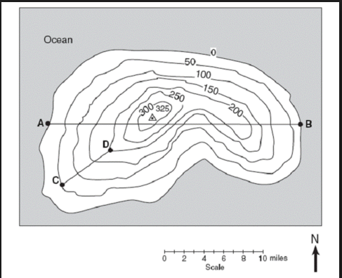
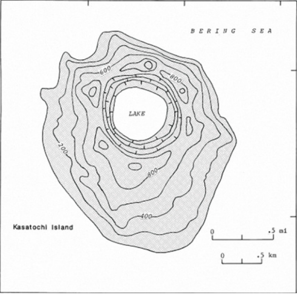
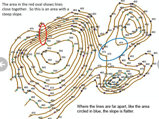
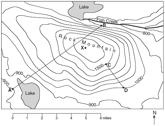
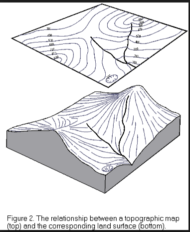
*Students must know how to read and explain topographic maps. A topographic map shows the detailed shapes of earth’s surface, along with its natural and human made features. *Student should know the difference between elevation and relief, elevation is the height above sea level of any point on earth’s surface and relief is the difference in elevation between the highest and lowest point in an area. Contour lines on the map are lines that connect points of equal elevation. Not every contour line is labeled on a topographic map, only the lines called index contour lines will be given an elevation. These index contour lines (darker, bold lines) give the map-reader a point of reference from which to begin reading the map, then the student may find the contour interval. The contour interval is the elevation difference between contour lines that are next to one another on the map, this changes from one map to another. The spacing between the contour lines indicates the slope of the landform, the slope is a measure of the steepness of the land. When contour lines are very close to one another this indicates a steep slope, when contour lines are much further apart then this means that the landform has a gradual incline. *Students should also be able to distinguish between an aerial view and a lateral view. The aerial view is an image representing the landform from above (view from the sky), while a lateral view is the side view of the landform (profile). At times some maps will include symbols such as highways, buildings, streams, rivers, etc. *Students should also know that the map scale is the relationship between a distance on the map and the actual distance on the ground; for example 1centimeter is equal to 1 kilometer. The student may use a ratio scale to determine the appropriate map scale when drawing a map. *The students should know that a satellite image consists of pictures of Earth taken from space. Geographic Information Systems (GIS) are computerized information systems used to store and analyze map data. GIS combine data collected from many different sources including satellites, scanners and aerial photographs. This type of data collection once took months to collect and now takes hours or minutes. Remote sensing is the process of collecting information about an area without coming into physical c contact with it. Satellites orbit earth repeatedly; therefore, images of a location made at different times can be used to study changes over time. *Students must look at satellite images of before and after events such as hurricane Katrina. |

|

|

|

|
|
March 3
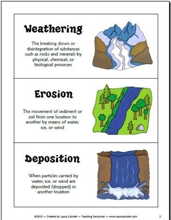
1. What types of landforms are there? DRY ERASE SHARE OUT 2. Effects of Weather on Landforms: Watch THREE videos: write 3 or more facts and share out 3. Vocabulary Foldable: IMAGE, DEFINITION, AND EXAMPLES Use Science-Saurus 188-193 and graphics below (click to make them bigger). WEATHERING CHEMICAL WEATHERING LANDFORMS PHYSICAL WEATHERING EROSION DEPOSITION HOMEWORK: FINISH FOLDABLE AND CLIMATE CHANGE ARTICLE (IF YOU FORGOT TO DO IT-GO BACK TO MARCH 2 ON UNIT 8) |

|
|
|
|
|
|


|

|

|

|

|
|
March 6, 2017
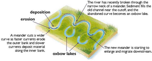
1. Erosion on the Ganges (STEM SCOPES 8.9 C) Video 1 and 3 https://ali1.acceleratelearning.com/scopes/193/elements/364404 2. Weathering and Erosion Station LABS Video Link Station 1: https://www.youtube.com/watch?v=_XnCTcjNpuc Homework: Finish any lab questions.... 
|
|
|
March 7 (absent 1/2 day AM) and 8 (absent 1/2 day PM), 2017
During the 1/2 day that I am here.... STEMSCOPES 8.9 C Video 2 https://ali1.acceleratelearning.com/scopes/193/elements/364405 2. EXPLORE: Modeling Weathering LAB with questions and graph Homework: Finish graph and lab questions During the other half that I am absent.... NOTES: COPY IN YOUR NOTEBOOK: USE CORNELL METHOD!!! QUIZ ON FRIDAY .... Pages 455-461 in GREEN textbook...and Questions on Page 461 Homework: Finish questions from green textbook if you did not finish during class.... |
GREEN TEXTBOOK QUESTIONS: (461)
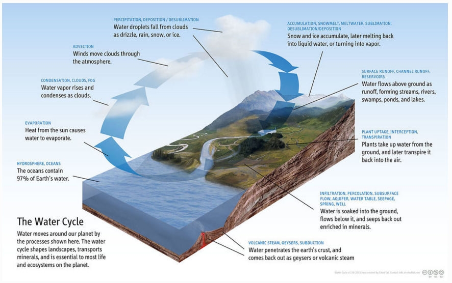
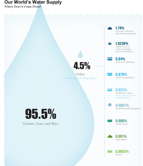
1. Describe the steps of the water cycle. 2. Why isn't most of the water on Earth's surface available for people to use? 3. Name four types of activities that can be sources of water pollution. 4. Explain why finding the source of water pollution can be difficult. 5. What is land subsistence? 6. Why should sewage be treated before being released to the environment. |

March 9, 2017 ABSENT ALL DAY
1. M/C Questions (TRY and CHECK): Pick up KEY from your sub and return it back.
2. Earth Science Day Book Reading and Fill-In Q's
Homework: FINISH CLASSWORK
QUIZ OVER WATER NOTES TOMORROW!
1. M/C Questions (TRY and CHECK): Pick up KEY from your sub and return it back.
2. Earth Science Day Book Reading and Fill-In Q's
Homework: FINISH CLASSWORK
QUIZ OVER WATER NOTES TOMORROW!
March 10, 2017 ABSENT ALL DAY
1. Take QUIZ on Freshwater NOTES (NO NOTES)
2. Computer LAB
Task 1: Landforms Site: http://studyjams.scholastic.com/studyjams/jams/science/rocks-minerals-landforms/landforms.htm
Use graphics below if the slides are going too fast! CLICK ON THEM TO MAKE THEM BIGGER!
1. Take QUIZ on Freshwater NOTES (NO NOTES)
2. Computer LAB
Task 1: Landforms Site: http://studyjams.scholastic.com/studyjams/jams/science/rocks-minerals-landforms/landforms.htm
Use graphics below if the slides are going too fast! CLICK ON THEM TO MAKE THEM BIGGER!

|

|

|

|

|

|

|

|
Weathering and Erosion: Watch and take quiz
Task 2: http://studyjams.scholastic.com/studyjams/jams/science/rocks-minerals-landforms/weathering-and-erosion.htm
Task 3: Watch Video: Write 5 facts or Summary
Task 2: http://studyjams.scholastic.com/studyjams/jams/science/rocks-minerals-landforms/weathering-and-erosion.htm
Task 3: Watch Video: Write 5 facts or Summary
SPRING BREAK EXTRA CREDIT:
LISTEN PODCAST BELOW AND WRITE A ONE PAGE ESSAY ABOUT THE TOPIC.
Take notes as you listen so you can use to write your essay. Typed and Printed. DUE on March 20, 2017.
Introduction: Topic sentence with 'hook'
3 Paragraphs for BODY explaining three different parts with details and examples from the podcast.
Conclusion-bring it all together and wrap it up.
March 20, 2017
1. DO NOW
2. Grade water quiz
3. What is a watershed? What effects do humans have on watersheds?
4. Watershed Mini-Activity
What is a watershed?
What do the brown circles represent?
What happened when you spray water over the mountain peaks? Use detail and explain using scientific vocabulary of what this represents in this were a real mountain.
What is the purpose of the paper towel? What would this represent in a real-life watershed?
What happens when there are factories near water sources and flooding on the surface occurs?
Draw and label the main parts of the water cycle.
Homework: NONE UNLESS YOU HAVE TO FINISH UP WORK FROM LAST WEEK!

|

|
|
March 21, 2017
1. DO NOW 2. READING TOPO MAPS RULES AND PRACTICE (NOTES) Homework: REVIEW RULES FOR MAKING TOPOGRAPHIC MAPS http://www.pkearthandspace.com/article/556/1/what-is-a-map |
|

|
|

|

|
|
|

|
|
|

|

March 23, 2014
1. DO NOW: STAAR Question
2. Check M/C questions and TOPO MAP STATIONS
3. TOPO MAP QUIZ
4. TOPO MAP PACKET
Homework: Finish 'PACKET'
1. DO NOW: STAAR Question
2. Check M/C questions and TOPO MAP STATIONS
3. TOPO MAP QUIZ
4. TOPO MAP PACKET
Homework: Finish 'PACKET'
|
March 24, 2017
0. Copy Notes about TYPES OF MAPS from board. 1. WATCH: https://vimeo.com/93971601 How has remote sensing been useful to Africa? 3-5 sentences. 2. WATCH: http://world.time.com/timelapse/ EXPLAIN THE TIME LAPSE FOR THE GLACIER... 3. FILL OUT SHEET: http://www.texasgateway.org/resource/maps-and-satellite-imageryl 4. IMAGES BELOW: These three images all show our local region. What is the difference in the types of maps? What would you say are the advantages oe each type of map. |

|

|

|
March 27, 2017
1. 'Picture This' and Vocabulary Matching...
2. Satellite Maps and Analysis Questions
3. TOPO MAP LABS/Stations
A. TOPO MAP ON A STICK
B. LANDFORM CASTS
C. CARD SORT
D. Region 4 STAAR Practice Cards
E. Using a stereo viewer for topographic maps
F. Reading a real topographic maps
Homework: NONE-REST, YOU HAVE STAAR MATH 3/28 AND STAAR READING 3/29 THE NEXT TWO DAYS...
March 30, 2017
1. DO NOW:
What's the difference? Map 1 and 2
What do you notice from 1989 Map to 2009 Map. Explain how this occurred.
2. Continue with Topographical MAP LABS
Homework: NONE
1. DO NOW:
What's the difference? Map 1 and 2
What do you notice from 1989 Map to 2009 Map. Explain how this occurred.
2. Continue with Topographical MAP LABS
Homework: NONE

|

|

|
March 31, 2017
1. Continue and Finish TOPO MAPS LAB
2. Using Google Earth to explore topography around the world... (BONUS POINTS IF YOU GET TO THIS PART)
Homework: STUDY FOR TEST
TEST: LANDFORMS, WEATHERING/EROSION/DEPOSITION, WATERSHED/SURFACE/GROUNDWATER, TOPOGRAPHICAL MAPS, Satellite Images
1. Continue and Finish TOPO MAPS LAB
2. Using Google Earth to explore topography around the world... (BONUS POINTS IF YOU GET TO THIS PART)
Homework: STUDY FOR TEST
TEST: LANDFORMS, WEATHERING/EROSION/DEPOSITION, WATERSHED/SURFACE/GROUNDWATER, TOPOGRAPHICAL MAPS, Satellite Images
April 3, 2017
1. TEST: LANDFORMS, WEATHERING/EROSION/DEPOSITION, WATERSHED/SURFACE/GROUNDWATER, TOPOGRAPHICAL MAPS
2. DYNA STUDY SHEETS (REVIEW CONTENT FOR STAAR MOCK TEST)
Homework: Review content from my website (go to the units) to refresh material. No more than 30 minutes!
1. TEST: LANDFORMS, WEATHERING/EROSION/DEPOSITION, WATERSHED/SURFACE/GROUNDWATER, TOPOGRAPHICAL MAPS
2. DYNA STUDY SHEETS (REVIEW CONTENT FOR STAAR MOCK TEST)
Homework: Review content from my website (go to the units) to refresh material. No more than 30 minutes!
April 4,5,6 (1/2 day on the 6th due to PT conferences)
BRING A BOOK TO READ IN CASE YOU FINISH EARLY
FULL TEST (2.5 Hours)
We will determine who needs specialized topic clinics from the results. Try your very best!
BRING A BOOK TO READ IN CASE YOU FINISH EARLY
FULL TEST (2.5 Hours)
We will determine who needs specialized topic clinics from the results. Try your very best!